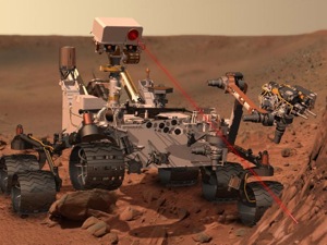
Joynt: Mars rover Curiosity images and panorama

http://www.geekwire.com/2012/super-awesome-curiosity-mars-landing-sunday/
September 2, 2012
NASA has revealed multiple images and panoramas since the Mars rover Curiosity reached the surface in early August. Photos captured by the rover detail the rocky terrain of the Mars landscape.
Mount Sharp is included in some of the images, which will be one of many destinations being explored by Curiosity. Areas around Mount Sharp were thought to show signs of exposure to liquid water.
The 360-degree Panorama view shows the Gale Crater, the landing site of the rover. The panorama comprises 140 images weaved together and edited in such a way to display the composition of the planet under lighting conditions similar to Earth.
Curiosity used its 34 millimeter mast camera for the panorama shot and additional shots are taken with its 100 millimeter mast camera.
Curiosity also used its ChemCam for the first time on a small rock called “Coronation.” Images showcasing the laser in action on a soil target nicknamed “Beechey” were shown in before-and-after shots to demonstrate the technique.
The ChemCam uses laser pulses to analyze Martian rock for analysis on the composition of the rocks and soil. An on-board spectrograph provides details on minerals by evaluating the composition of the resulting plasmic material.
Curiosity’s next destination is an area called Glenelg, where it will use a series of instruments to drill into the bedrock for testing.


