Hurricanes churn in Atlantic as Tropical Storm Karl forms in Caribbean
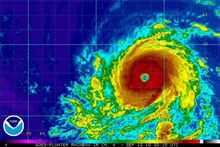
Photo courtesy: NOAA via CNN Wire Service
Satellite rainbow infrared image of Hurricane Igor on Sept. 12 at 3:15 p.m. CDT.
September 14, 2010
MIAMI, Florida — Tropical Storm Karl formed Tuesday afternoon in the northwest Caribbean Sea, prompting coastal warnings by the Mexican government, the National Hurricane Center said.
At 6 p.m. CDT, Karl was 270 miles east of Chetumal, Mexico. It had maximum sustained winds of 40 mph and was traveling west-northwest at 15 mph.
The warning was in effect for the east coast of the Yucatan Peninsula from Chetumal to Cabo Catoche. A tropical storm watch was called for Belize.
Karl, a small storm, will move over the Yucatan on Wednesday, the hurricane center said, and bring a storm surge and 3-5 inches of rainfall.
The Atlantic, meanwhile, gained a second hurricane overnight as Tropical Storm Julia strengthened into a Category 1 storm, the National Hurricane Center reported.
Julia joins Hurricane Igor, which weakened early Tuesday but showed signs of getting stronger later in the day. Igor maintained its status as a powerful Category 4 storm as it churned far from land.
At 6 p.m. CDT, Igor had top sustained winds of 145 mph and was moving to the west-northwest at 8 mph, forecasters said. The storm’s center was about 655 miles east of the northern Leeward Islands.
Igor, which started as a tropical storm on Saturday, rapidly intensified from a Category 2 to a Category 4 storm Sunday.
“Some fluctuations in intensity are possible during the next couple of days, but Igor is expected to remain a dangerous hurricane through Thursday,” the center said, and it could have some effect on Bermuda.
Hurricane-force winds extended up to 45 miles from Igor’s center, and tropical storm-force winds could be felt up to 205 miles outward, according to the center.
While the storm is expected to stay north of the Caribbean islands, the islands are expected to experience dangerous surf conditions, along with some wind and rain because of Igor’s size, forecasters said.
Meanwhile, in the far eastern Atlantic, Julia kept pace, becoming the fifth hurricane of the Atlantic season.
As of 6 p.m. CDT, Julia’s center was about 405 miles west-northwest of the southernmost Cape Verde Islands. The storm’s maximum sustained winds increased from 75 mph early Tuesday to 85 mph, and it was moving west-northwest at 9 mph.
Tracking maps show Julia haveing little change in strength into Wednesday, but it is expected to see slow weakening by Thursday. It is not expected to threaten land.


