Hurricanes Julia, Igor downgraded as Karl intensifies
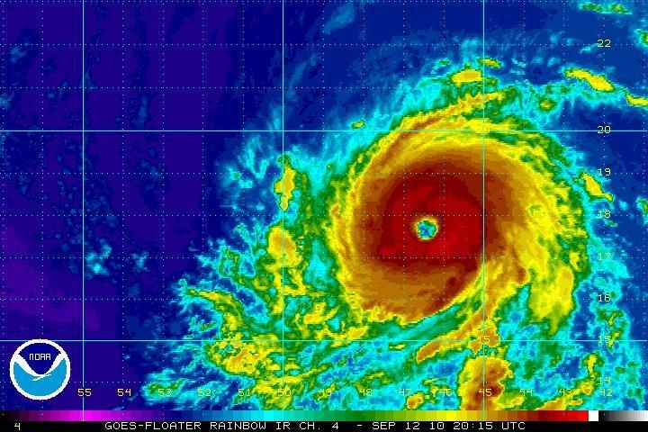
Satellite rainbow infrared image of Hurricane Igor on Sept. 12 at 3:15 p.m. CDT.
September 16, 2010
MIAMI — Category 1 Hurricane Karl could approach major hurricane strength before its center reaches the Mexican coast Friday, according to the National Hurricane Center.
As of 3 p.m. CDT Thursday, Karl was about 165 miles east of Veracruz, Mexico, moving west at around 12 miles per hour.
Over the next 24 hours, it’s expected to continue moving west. The National Hurricane Center said the storm is expected to make landfall as a hurricane just after midday Friday. It is expected to weaken quickly once it enters the Mexican mountains.
“Strengthening is likely, and Karl could approach major hurricane strength before the center reaches the Mexican coast,” the hurricane center said.
A storm reaches major hurricane strength on the Saffir-Simpson scale when when it has sustained winds of 111 mph. At 1 p.m., Karl’s maximum sustained winds were 80 mph.
The government of Mexico has issued a hurricane warning for the eastern coast of Mexico from Palma Sola to southward to Veracruz. A tropical storm warning was in effect from south of Veracruz to Punta el Lagarto.
The National Hurricane Center warns that Karl’s storm surge could raise water levels as much as 6-9 feet above normal in the area where the center makes landfall. The surge will likely be accompanied by large and destructive waves. The storm is currently expected to produce rainfall accumulations of 5-10 inches along the central and southern Mexican Gulf Coast region, while up to 15 inches are possible in the interior mountains.
Meanwhile, east of the Gulf of Mexico, two more storms weakened in the Atlantic Ocean.
At 3 p.m. CDT, Hurricane Igor had maximum sustained winds near 125 mph, moving down to Category 3 strength. The storm was moving toward the northwest at 8 mph, but forecasters say its forward speed is expected to increase in the next couple of days.
Igor was 405 miles northeast of the Northern Leeward Islands.
Hurricane-force winds from the powerful Category 4 storm extended up to 105 miles from its center, and tropical storm-force winds could be felt up to 290 miles outward, according to the center.
Large swells generated by Hurricane Igor will continue to affect the Leeward Islands, Puerto Rico and the Virgin Islands, according to the weather agency. These swells are expected to cause dangerous surf- and rip-current conditions in Bermuda over the next several days and are expected to reach portions of the Bahamas later Thursday. These swells will reach the eastern coast of the U.S. late Thursday and continue through the weekend.
In the far eastern Atlantic, Julia was downgraded to a Category 1 hurricane and continued to weaken.
As of 3 p.m. CDT, Julia’s maximum sustained winds were 85 mph. The storm was moving west-northwest at speeds around 25 mph. The storm’s center was about 1,325 miles southwest of the Azores Islands.
Julia is expected to slowly weaken and could become a tropical storm by Friday evening.