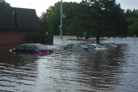
South Skunk River hits new record; Squaw Creek records 2nd highest crest
August 11, 2010
Rainfall late Tuesday into Wednesday totaling 3.86 inches was enough to elevate flooding in the Ames area to record levels.
Both the South Skunk River and the Squaw Creek have been out of their banks since earlier this week, according to information from the National Weather Service.
The South Skunk River at U.S. Highway 30 set a new record when it crested at 26.72 feet at about 10 a.m. Wednesday. The previous record was 25.57 feet recorded on June 27, 1975.
Cresting occured on the Squaw Creek at Lincoln Way at about 8 a.m. Wednesday. The creek crested at 18.13 feet, just shy of the record 18.54 feet set on June 9, 1993.
The South Skunk River and Squaw Creek have been falling since their crests, but the forecast for the rest of the week could cause levels to rise again.
The National Weather Service forecasts dry weather for Ames Wednesday night and Thursday.
The next chance for rain comes on Thursday night into Friday. The chance of thunderstorms on Thursday is at 50 percent. On Friday the chance for heavy rain is at 70 percent.
Brad Fillbach, a hydrometeological technician with the National Weather Service, said the possibility is there for heavy rains during that period. It is possible that Ames could see as much as 2-3 inches of rain.
Fillbach said the ground in Ames already is very saturated.
“Thankfully right now all three river (stations) in Ames are going down and you could see another 24 hours of dropping,” Fillbach said.
Significant rainfall in Ames or to the north could force the river and creek out of their banks again. Fillbach said water levels could near the levels seen on Wednesday.


